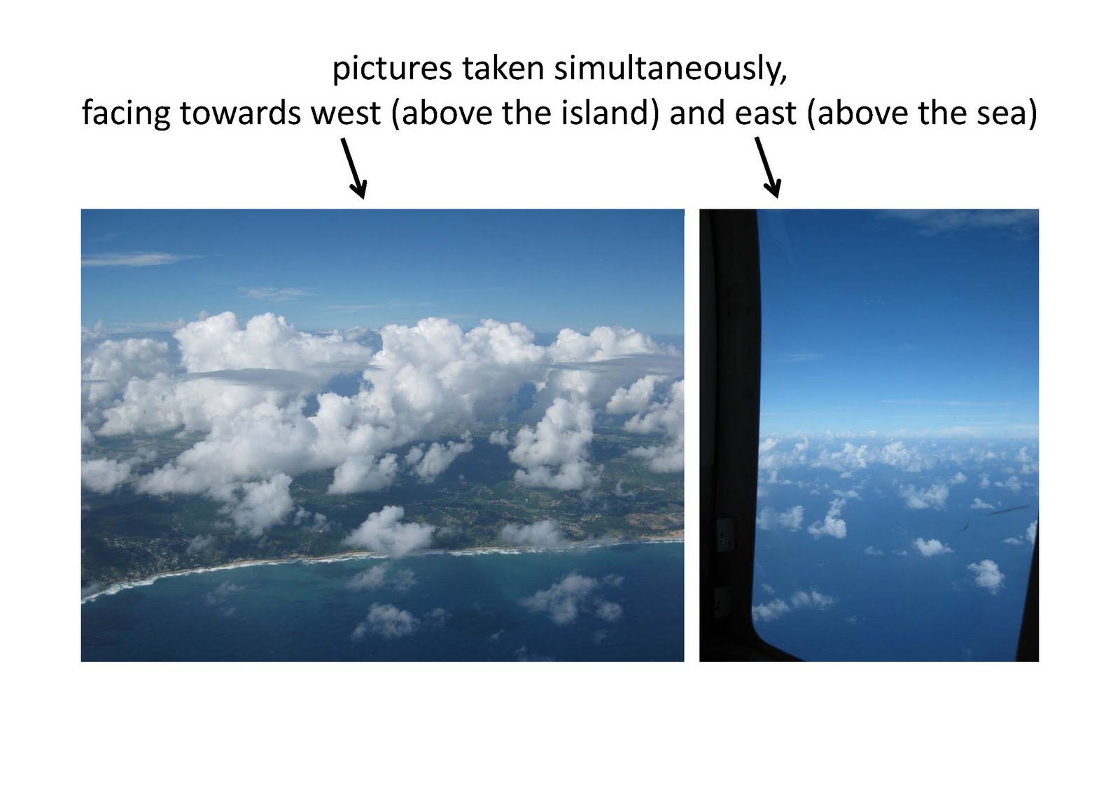
 Today we took off delayed because we had to wait until a shower passed by. ACTOS became airborne at 14:00 UTC (10:00 local). At the beginning we performed a low level leg at 200 ft (ACTOS) heading to C1 near Ragged Point. Afterwards, we had to ascend to avoid a shower at the east coast and climbed up to 8500 ft above the cloud top. Cloud base was located at about 1500 ft. Unfortunately, the cloud situation was dominated by a heavy shower nearby so cloud chasing became a difficult task. Cloud top was highly variable (see picture) and we decided to descend and tried to catch the cumulus clouds at about 3000 ft. On our way back we had to ascend again to avoid another shower and climbed up to 10000 ft. Above this shower we found a stratiform layer covering nearly the whole island, which confronted the pilots with a new task: cloud hole hunting. Finally, we found one to descend below and performed a last horizontal leg at 2000 ft heading Grantley Adams.
Freitag, 26. November 2010
Cloud hole hunting
Today we took off delayed because we had to wait until a shower passed by. ACTOS became airborne at 14:00 UTC (10:00 local). At the beginning we performed a low level leg at 200 ft (ACTOS) heading to C1 near Ragged Point. Afterwards, we had to ascend to avoid a shower at the east coast and climbed up to 8500 ft above the cloud top. Cloud base was located at about 1500 ft. Unfortunately, the cloud situation was dominated by a heavy shower nearby so cloud chasing became a difficult task. Cloud top was highly variable (see picture) and we decided to descend and tried to catch the cumulus clouds at about 3000 ft. On our way back we had to ascend again to avoid another shower and climbed up to 10000 ft. Above this shower we found a stratiform layer covering nearly the whole island, which confronted the pilots with a new task: cloud hole hunting. Finally, we found one to descend below and performed a last horizontal leg at 2000 ft heading Grantley Adams.

Flight #15
Our 15th research flight took place yesterday, Thursday Nov. 25th. As often before, we first headed out east to the sea and then flew north along the coastline, above the water, at a heights of about 200ft above ground (for ACTOS). When we were at our waypoint “C1” (east of Ragged Point), we started a profile, heading north, that carried us up to our maximum heights of 8000ft. The cloud base was at about 2000ft, and higher up there were again small cloud layers at about the cloud top heights (at about 6000ft - well, a few cumulus clouds extended above that height). After having finished the profile we tried to sample these thin layers for a while. However, they were not only thin but also not very stable, so we have to see in the data how much of them we really sampled. In general, there were more of these small cloud layers and also more and larger cumulus clouds above land than above the sea.  We also chased cumulus clouds for a while (there were enough around). We were going round and round and round, so that we eventually were at the north-west-coast of Barbados. We went back to the eastern side of the island, and descended back south, above water, towards “C1”, at the heights of the clouds, from about 5500ft to 2000ft, without much contact to clouds (really only a few seconds). Having reached “C1”, we flew a last level leg below cloud base, at 1500ft, towards the airport.
 We also chased cumulus clouds for a while (there were enough around). We were going round and round and round, so that we eventually were at the north-west-coast of Barbados. We went back to the eastern side of the island, and descended back south, above water, towards “C1”, at the heights of the clouds, from about 5500ft to 2000ft, without much contact to clouds (really only a few seconds). Having reached “C1”, we flew a last level leg below cloud base, at 1500ft, towards the airport.
Donnerstag, 25. November 2010
Technical Info II
The 1-micron wire did not survived and has been replaced by a 2.5-micron wire. The LiCor will run as an open-path system until the end of the campaign. The CCNC has been removed for calibration and will not join the flight(s) on Friday (Nov 26th).
The spare part for SMART-Helios has arrived and is currently integrated. Flight hours for two research flights are left and hopefully the flights will be performed with a fully running SMART.
The spare part for SMART-Helios has arrived and is currently integrated. Flight hours for two research flights are left and hopefully the flights will be performed with a fully running SMART.
Mittwoch, 24. November 2010
Per steam engine from Grenada to Barbados?
This morning we decided to fly again to Ragged Point. After a first low level leg at 300 ft (ACTOS) we climbed up to 8000 ft for a vertical profile. Unfortunately, all clouds near the east coast disappeared, so we decided to go to our measurement area south of the island. Arriving there we performed horizontal legs at 4000 ft and 3000 ft and prompt some nice cumuli showed up. At 3000 ft ACTOS sampled lots of clouds with various cloud top heights and cloud base around 2000 ft. It was amazing to follow the fast development of these clouds from small frazzles to mature ones. The liquid water content reached maximum values around 1 g m-3 and the FastCPC recorded high fluctuations in the particle number concentration (interstitial) at cloud edges.  In between some looked like smoke clouds from steam engines (see picture). Finally, we made a horizontal leg below cloud base at about 1500 ft on our way back to the Concorde Center.
 In between some looked like smoke clouds from steam engines (see picture). Finally, we made a horizontal leg below cloud base at about 1500 ft on our way back to the Concorde Center.
Technical Info
After the first flight (Nov 24th), the LiCor-System has been changed from a closed to an open-path system. A few spikes during cloud penetrations might occur due to scattering!The UFT is now running with an 1-micron wire; new settings: I = 0.1 mA, G = 100 (former settings: I = 0.2 mA and G = 200). Both changes are in order to increase resolution but with a slightly increased chance of malfunction.
Dienstag, 23. November 2010
Another nice cloud flight
Today was another nice c hance for chasing trade wind cumulus clouds. Take-off was around 9:30 local. We went to the open sea near Ragged Point and started a full profile from 80 m to 2400 m above sea level. Afterwards we stayed at this highest level and and flew a 10-min long horizontal leg. Many cumulus clouds were below us but many of them had higher cloud tops. Nice clouds were all around us, thus it was not difficult to spent the rest of the flight with cloud measurements. We passed various
 cumulus clouds in different heights which was really impressive, because all these cauliflower heads around were still growing. It was also interesting to see how fuzzy most of the cloud edges were and how quickly they were changed.
 hance for chasing trade wind cumulus clouds. Take-off was around 9:30 local. We went to the open sea near Ragged Point and started a full profile from 80 m to 2400 m above sea level. Afterwards we stayed at this highest level and and flew a 10-min long horizontal leg. Many cumulus clouds were below us but many of them had higher cloud tops. Nice clouds were all around us, thus it was not difficult to spent the rest of the flight with cloud measurements. We passed various
 cumulus clouds in different heights which was really impressive, because all these cauliflower heads around were still growing. It was also interesting to see how fuzzy most of the cloud edges were and how quickly they were changed.
Montag, 22. November 2010
Flight #12
Today we decided again to fly to the east coast. After takeoff we performed a low level leg along the coast line on our wa y to Ragged Point at 300 ft (ACTOS) above sea level. Afterwards, we ascended to get a vertical profile near the east coast. Reaching 8000 ft we recognized a very stratiform cloud which was located just a few hundred feet higher. So the pilots asked for permission to climb up which was immediately approved by ATC and we performed measurements inside a homogeneou
 s cloud at 8500 ft for more than 10 minutes (see upper picture). A very nice optical phenomenon came along with us - within the shadow of the helicopter a glory appeared (lower picture). Thereafter, we descended to sample cumulus clouds at various altitudes from 4000 ft to 6000 ft for another 45 minutes. Cloud base was mostly located near 2000 ft and cloud top very variable. Finally, we flew again horizontal legs under cloud free conditions at 3000 ft and a low level leg near Ragged Point on our way back to Concorde Helipad.
 y to Ragged Point at 300 ft (ACTOS) above sea level. Afterwards, we ascended to get a vertical profile near the east coast. Reaching 8000 ft we recognized a very stratiform cloud which was located just a few hundred feet higher. So the pilots asked for permission to climb up which was immediately approved by ATC and we performed measurements inside a homogeneou
 s cloud at 8500 ft for more than 10 minutes (see upper picture). A very nice optical phenomenon came along with us - within the shadow of the helicopter a glory appeared (lower picture). Thereafter, we descended to sample cumulus clouds at various altitudes from 4000 ft to 6000 ft for another 45 minutes. Cloud base was mostly located near 2000 ft and cloud top very variable. Finally, we flew again horizontal legs under cloud free conditions at 3000 ft and a low level leg near Ragged Point on our way back to Concorde Helipad.
Abonnieren
Posts (Atom)