 Today we took off delayed because we had to wait until a shower passed by. ACTOS became airborne at 14:00 UTC (10:00 local). At the beginning we performed a low level leg at 200 ft (ACTOS) heading to C1 near Ragged Point. Afterwards, we had to ascend to avoid a shower at the east coast and climbed up to 8500 ft above the cloud top. Cloud base was located at about 1500 ft. Unfortunately, the cloud situation was dominated by a heavy shower nearby so cloud chasing became a difficult task. Cloud top was highly variable (see picture) and we decided to descend and tried to catch the cumulus clouds at about 3000 ft. On our way back we had to ascend again to avoid another shower and climbed up to 10000 ft. Above this shower we found a stratiform layer covering nearly the whole island, which confronted the pilots with a new task: cloud hole hunting. Finally, we found one to descend below and performed a last horizontal leg at 2000 ft heading Grantley Adams.
Freitag, 26. November 2010
Cloud hole hunting
Today we took off delayed because we had to wait until a shower passed by. ACTOS became airborne at 14:00 UTC (10:00 local). At the beginning we performed a low level leg at 200 ft (ACTOS) heading to C1 near Ragged Point. Afterwards, we had to ascend to avoid a shower at the east coast and climbed up to 8500 ft above the cloud top. Cloud base was located at about 1500 ft. Unfortunately, the cloud situation was dominated by a heavy shower nearby so cloud chasing became a difficult task. Cloud top was highly variable (see picture) and we decided to descend and tried to catch the cumulus clouds at about 3000 ft. On our way back we had to ascend again to avoid another shower and climbed up to 10000 ft. Above this shower we found a stratiform layer covering nearly the whole island, which confronted the pilots with a new task: cloud hole hunting. Finally, we found one to descend below and performed a last horizontal leg at 2000 ft heading Grantley Adams.
Flight #15
Our 15th research flight took place yesterday, Thursday Nov. 25th. As often before, we first headed out east to the sea and then flew north along the coastline, above the water, at a heights of about 200ft above ground (for ACTOS). When we were at our waypoint “C1” (east of Ragged Point), we started a profile, heading north, that carried us up to our maximum heights of 8000ft. The cloud base was at about 2000ft, and higher up there were again small cloud layers at about the cloud top heights (at about 6000ft - well, a few cumulus clouds extended above that height). After having finished the profile we tried to sample these thin layers for a while. However, they were not only thin but also not very stable, so we have to see in the data how much of them we really sampled. In general, there were more of these small cloud layers and also more and larger cumulus clouds above land than above the sea.  We also chased cumulus clouds for a while (there were enough around). We were going round and round and round, so that we eventually were at the north-west-coast of Barbados. We went back to the eastern side of the island, and descended back south, above water, towards “C1”, at the heights of the clouds, from about 5500ft to 2000ft, without much contact to clouds (really only a few seconds). Having reached “C1”, we flew a last level leg below cloud base, at 1500ft, towards the airport.
 We also chased cumulus clouds for a while (there were enough around). We were going round and round and round, so that we eventually were at the north-west-coast of Barbados. We went back to the eastern side of the island, and descended back south, above water, towards “C1”, at the heights of the clouds, from about 5500ft to 2000ft, without much contact to clouds (really only a few seconds). Having reached “C1”, we flew a last level leg below cloud base, at 1500ft, towards the airport.
Donnerstag, 25. November 2010
Technical Info II
The 1-micron wire did not survived and has been replaced by a 2.5-micron wire. The LiCor will run as an open-path system until the end of the campaign. The CCNC has been removed for calibration and will not join the flight(s) on Friday (Nov 26th).
The spare part for SMART-Helios has arrived and is currently integrated. Flight hours for two research flights are left and hopefully the flights will be performed with a fully running SMART.
The spare part for SMART-Helios has arrived and is currently integrated. Flight hours for two research flights are left and hopefully the flights will be performed with a fully running SMART.
Mittwoch, 24. November 2010
Per steam engine from Grenada to Barbados?
This morning we decided to fly again to Ragged Point. After a first low level leg at 300 ft (ACTOS) we climbed up to 8000 ft for a vertical profile. Unfortunately, all clouds near the east coast disappeared, so we decided to go to our measurement area south of the island. Arriving there we performed horizontal legs at 4000 ft and 3000 ft and prompt some nice cumuli showed up. At 3000 ft ACTOS sampled lots of clouds with various cloud top heights and cloud base around 2000 ft. It was amazing to follow the fast development of these clouds from small frazzles to mature ones. The liquid water content reached maximum values around 1 g m-3 and the FastCPC recorded high fluctuations in the particle number concentration (interstitial) at cloud edges.  In between some looked like smoke clouds from steam engines (see picture). Finally, we made a horizontal leg below cloud base at about 1500 ft on our way back to the Concorde Center.
 In between some looked like smoke clouds from steam engines (see picture). Finally, we made a horizontal leg below cloud base at about 1500 ft on our way back to the Concorde Center.
Technical Info
After the first flight (Nov 24th), the LiCor-System has been changed from a closed to an open-path system. A few spikes during cloud penetrations might occur due to scattering!The UFT is now running with an 1-micron wire; new settings: I = 0.1 mA, G = 100 (former settings: I = 0.2 mA and G = 200). Both changes are in order to increase resolution but with a slightly increased chance of malfunction.
Dienstag, 23. November 2010
Another nice cloud flight
Today was another nice c hance for chasing trade wind cumulus clouds. Take-off was around 9:30 local. We went to the open sea near Ragged Point and started a full profile from 80 m to 2400 m above sea level. Afterwards we stayed at this highest level and and flew a 10-min long horizontal leg. Many cumulus clouds were below us but many of them had higher cloud tops. Nice clouds were all around us, thus it was not difficult to spent the rest of the flight with cloud measurements. We passed various
 cumulus clouds in different heights which was really impressive, because all these cauliflower heads around were still growing. It was also interesting to see how fuzzy most of the cloud edges were and how quickly they were changed.
 hance for chasing trade wind cumulus clouds. Take-off was around 9:30 local. We went to the open sea near Ragged Point and started a full profile from 80 m to 2400 m above sea level. Afterwards we stayed at this highest level and and flew a 10-min long horizontal leg. Many cumulus clouds were below us but many of them had higher cloud tops. Nice clouds were all around us, thus it was not difficult to spent the rest of the flight with cloud measurements. We passed various
 cumulus clouds in different heights which was really impressive, because all these cauliflower heads around were still growing. It was also interesting to see how fuzzy most of the cloud edges were and how quickly they were changed.
Montag, 22. November 2010
Flight #12
Today we decided again to fly to the east coast. After takeoff we performed a low level leg along the coast line on our wa y to Ragged Point at 300 ft (ACTOS) above sea level. Afterwards, we ascended to get a vertical profile near the east coast. Reaching 8000 ft we recognized a very stratiform cloud which was located just a few hundred feet higher. So the pilots asked for permission to climb up which was immediately approved by ATC and we performed measurements inside a homogeneou
 s cloud at 8500 ft for more than 10 minutes (see upper picture). A very nice optical phenomenon came along with us - within the shadow of the helicopter a glory appeared (lower picture). Thereafter, we descended to sample cumulus clouds at various altitudes from 4000 ft to 6000 ft for another 45 minutes. Cloud base was mostly located near 2000 ft and cloud top very variable. Finally, we flew again horizontal legs under cloud free conditions at 3000 ft and a low level leg near Ragged Point on our way back to Concorde Helipad.
 y to Ragged Point at 300 ft (ACTOS) above sea level. Afterwards, we ascended to get a vertical profile near the east coast. Reaching 8000 ft we recognized a very stratiform cloud which was located just a few hundred feet higher. So the pilots asked for permission to climb up which was immediately approved by ATC and we performed measurements inside a homogeneou
 s cloud at 8500 ft for more than 10 minutes (see upper picture). A very nice optical phenomenon came along with us - within the shadow of the helicopter a glory appeared (lower picture). Thereafter, we descended to sample cumulus clouds at various altitudes from 4000 ft to 6000 ft for another 45 minutes. Cloud base was mostly located near 2000 ft and cloud top very variable. Finally, we flew again horizontal legs under cloud free conditions at 3000 ft and a low level leg near Ragged Point on our way back to Concorde Helipad.
Sonntag, 21. November 2010
Clouds, clouds and music
 The second flight of this day started at 18:28 UTC. During noon, small cumulus clouds developed and started to grow. Since the most clouds were located at the east coast, we decided to fly to Ragged Point. After a leg at a height of 240 feet (Actos height) above the ocean, we climbed up to 10000 feet. As we looked down, lots of nice clouds were below us. We ask the pilots to descent and to chase for clouds. During chasing, we could follow the development of tiny cumulus clouds to mature ones.
  The first picture shows the cloud situation during the profile and the second one only 20 minutes later at the height of the clouds. Afterwards, we flew back to the airport at a height of 3000 feet.
Finally, the pilots did a good job, caught a lot of clouds and provided a nice entertainment program. I really enjoyed my first research flight.
Clouds on vacation
Today we performed again an early flight and took off at 9:30 local (13:30 UTC).  The LIDAR quicklook from Deebles Point (picture on the right, thanks to MPI Hamburg!) looked very promising and indicated a lifted layer with enhanced depolarization ratio at ca. 2 km above sea level and another layer reaching from sea level to about 1 km. Since there were no clouds we decided to focus on these layers.
Close after takeoff the Helicopter turned towards our measurement area south of Grantley Adams International Airport (GAIA, picture below). On our way to the reserved area we performed a low level leg at about 800 ft above sea level, so ACTOS wa s at about 300 ft. Afterwards, we ascended to 10000 ft to make a full vertical profile and stayed there for at least ten minutes. Thereafter, we started our "aerosol layer chasing" and performed several horizontal legs at 6000 ft, 2000 ft, 1500 ft and again a low level leg. The data will tell us, if we caught the different layers.
Unfortunately, HELIOS is still forced to stay on ground but today there were lots of cirrus clouds... Finally, although there were no clouds within our duration my first research flight was a very interesting one.
PS: Clouds are back and ACTOS is again airborne at the moment...
 The LIDAR quicklook from Deebles Point (picture on the right, thanks to MPI Hamburg!) looked very promising and indicated a lifted layer with enhanced depolarization ratio at ca. 2 km above sea level and another layer reaching from sea level to about 1 km. Since there were no clouds we decided to focus on these layers.
Close after takeoff the Helicopter turned towards our measurement area south of Grantley Adams International Airport (GAIA, picture below). On our way to the reserved area we performed a low level leg at about 800 ft above sea level, so ACTOS wa
 s at about 300 ft. Afterwards, we ascended to 10000 ft to make a full vertical profile and stayed there for at least ten minutes. Thereafter, we started our "aerosol layer chasing" and performed several horizontal legs at 6000 ft, 2000 ft, 1500 ft and again a low level leg. The data will tell us, if we caught the different layers.
Unfortunately, HELIOS is still forced to stay on ground but today there were lots of cirrus clouds... Finally, although there were no clouds within our duration my first research flight was a very interesting one.
PS: Clouds are back and ACTOS is again airborne at the moment...
Samstag, 20. November 2010
ACTOS is back but without HELIOS
The last three days we learned the meaning of bank holidays: our helicopter had to stay on ground until some money found its way from one bank in Leipzig to another one on Barbados which really still takes days. However, it arrived yesterday and we are allowed to fly again. Today in the morning, the weather conditions were not suitable to start a measurement flight: we had showers and high cumulus towers all around. Thus we were waiting for our chance and it came: Around noon the show ers were gone and the clouds to the east looked nice and calm.
As usual, HELIOS started first, but in the last minute he realized that Christoph was not there to carry him. This must have been a real shock for HELIOS and disturbed immediately his power supply.
Bad-smelling smoke came out and the start was stopped. A second try was done without HELIOS and was more succesful. The measurements started with a full profile from 100 m above water to approximately 2400 m. During the profile we passed several cumulus clouds with variable height, thickness and cloud base. On top of these clouds was again a stratified cloud layer, today it was more homogeneous than last time. Our maximum height was above this layer and a vie w from there is shown on the upper picture. A first horizontal leg was flown with ACTOS in this cloud before we declined below (see picture on the left) and started the chasing of cumulus clouds. This was really nice and effective and PICT had again the chance to measure lots of droplets. Close to the end of the flight the small cumulus clouds dissappeared and larger ones were visible near the airport. Very soon after landing it started raining again. So we had at least one nice flight today and hope that HELIOS will recover and be back with us soon!
 ers were gone and the clouds to the east looked nice and calm.
As usual, HELIOS started first, but in the last minute he realized that Christoph was not there to carry him. This must have been a real shock for HELIOS and disturbed immediately his power supply.
Bad-smelling smoke came out and the start was stopped. A second try was done without HELIOS and was more succesful. The measurements started with a full profile from 100 m above water to approximately 2400 m. During the profile we passed several cumulus clouds with variable height, thickness and cloud base. On top of these clouds was again a stratified cloud layer, today it was more homogeneous than last time. Our maximum height was above this layer and a vie
 w from there is shown on the upper picture. A first horizontal leg was flown with ACTOS in this cloud before we declined below (see picture on the left) and started the chasing of cumulus clouds. This was really nice and effective and PICT had again the chance to measure lots of droplets. Close to the end of the flight the small cumulus clouds dissappeared and larger ones were visible near the airport. Very soon after landing it started raining again. So we had at least one nice flight today and hope that HELIOS will recover and be back with us soon!
Donnerstag, 18. November 2010
Wenn's mal wieder länger dauert...
Da der Barbados-Alltag mal wieder von längeren Wartepausen geprägt ist, soll auch dieser Blogeintrag unter dem Motto "Warten" stehen. Das kleine Video zeigt einige Motive aus dem Ganztagstest der SMART-HELIOS Kamera vom 10.11., wo ACTOS und HELIOS am Boden bleiben mussten (wie jetzt auch) und stattdessen das Starten und Landen mit Wasserkanistern und Fahne geübt wurde... Enjoy!
Dienstag, 16. November 2010
PICTs erster Flug
Für den heutigen Jungfernflug von PICT waren die Bedingungen optimal - es konnten viele Wolken "gejagt" und durchflogen werden. Somit konnte das Instrument ordentlich auf Herz und Nieren getestet werden. Die ersten Ergebnisse sind durchaus zufriedenstellend. Als Beispiel sind hier Zeitreihen von Tropfendurchmesser und Tropfengeschwindigkeit, sowie die dazugehörigen Histogramme gezeigt. Man kann gut die Lücke zwischen zwei Wolkenteilen erkennen und eine trimodale Struktur in den Tropfendurchmessern.


The day without power
While preparing ACTOS for the start this morning we had a complete power failure at the container. This seems to be a serious problem and the power did not come back until now (17:00 local). However, we were able to improvise and prepared ACTOS for another flight. PICT was implemented and Tina was curious to see some real cloud data.
The helicopter started at 10:30 local and flew again to the area close to Ragged Point. There, a vertical profile up to 8000 ft was flown above the ocean. There were only few thin clouds over the ocean and more 'real' cumulus clouds over the island. Thus, cloud chasing looked more successful over the island and we did t hat. I realized that the battery power of ACTOS was lower than the days before and decreased more rapidly. After roughly half an hour of cloud chasing I decided to go back since the power was really low. A few minutes later ACTOS shut off and the measurements of course were over. Back on ground the batteries were fine and we could not really explain the power failure during the flight. However, it was a nice flight with many cloud contacts and suitable to check if the new PICT was working well.
The helicopter started at 10:30 local and flew again to the area close to Ragged Point. There, a vertical profile up to 8000 ft was flown above the ocean. There were only few thin clouds over the ocean and more 'real' cumulus clouds over the island. Thus, cloud chasing looked more successful over the island and we did t
 hat. I realized that the battery power of ACTOS was lower than the days before and decreased more rapidly. After roughly half an hour of cloud chasing I decided to go back since the power was really low. A few minutes later ACTOS shut off and the measurements of course were over. Back on ground the batteries were fine and we could not really explain the power failure during the flight. However, it was a nice flight with many cloud contacts and suitable to check if the new PICT was working well.
Montag, 15. November 2010
Was lange währt...
 Es ist da! Unser letztes Instrument, um vollständige Passatwindwolken-Charakteristiken zu erstellen ist nun endlich eingetroffen: das PICT. Mittels Phase Doppler Interferometry können nun nicht nur Informationen bezüglich der Tropfengeschwindigkeit (dazu haben wir ja schon das LDA), sondern auch über die Tropfengröße erhalten werden. Nach ersten Test wurde es heute an ACTOS angebracht und wird morgen seinen ersten Flug machen. Wir sind schon alle gespannt auf die Daten, die es liefern wird!
New cloud layer discovered

Today we performed one flight in the morning with similar weather conditions as the last days. We started at 10:00 local and flew again directly to the area near Ragged Point. The flight pattern started with a vertical profile up to 8000 ft followed by a horizontal leg in that height. Beeing up there we realized a thin cloud layer in the cloud top height of cumulus clouds. This layer has not been there the days before. We dropped
 ACTOS into this layer and followed the cloud for a while. The liquid water content (LWC) was between 0.1 and 0.3 g/cm^3. After few minutes this layer disappeared and we started chasing cumulus clouds again. They were highly variable and still growing, the maximum LWC exceeded 1 g/m^3 several times. The flight pattern probably looks very chaotic but obviously the pilots enjoyed the cloud chasing. We did it for a while until our flight time was almost over. Before flying back we made another horizontal leg below cloud base for comparison with ground measurements. On the way back to the airport we passed Ragged Point and Deebles Point again, best wishes to all the colleagues measuring there!
Sonntag, 14. November 2010
Chaotic clouds

After some trouble-shooting in the morning we finally could take off at 1:20pm local. We tried again to heading off the East coast around Ragged Point but the flight startet with 8 minutes of hovering in 50 m with ACTOS stil on the field until we got finally flight permission from ATC.
We defined a 10 km long leg in the North of Ragged Point to avoid any conflict with commercial traffic and were nearly free to do what we want. After a profile up to 7500 ft we tried to sample clouds and we got a lot of them in different heights - sometimes at cloud top, sometimes at the cloud edge.
Again, cloud tops were very inhomogeneous. Most clouds were still actively growing which was quite a challenge for the pilots. A lot of clouds produced precipiation - even a few very shallow ones which resulted in many rainbows below us. Sometimes virgae could be observed between the clouds (see photo above). After a final horizontal leg in 1000 ft above sea level ACTOS and the helicopter got washed in a slight shower.

This was definitively the flight with the most cloud contacts - we're getting better!
Samstag, 13. November 2010
CCN measurements on ACTOS
 On board of ACTOS we have a miniaturized CCNc, contributed by Greg Roberts, who is here in Barbados with us. The instrument has been measuring very reliably during all of the 5 flights we had so far, and once ACTOS is back in place, the data can be viewed almost immediately (within minutes, really). This is a very nice feature, as it can give us some clues about what was sampled during the flights, and this then can tell us which heights might be interesting for the second flight of the day.
 The way the mini-CCNc was set up so far, it measured CCN at a super-saturation of 0.3%. The plots show the CCN number concentration measured during the initial profiles of 4 of the 5 different flights (the morning flight of yesterday, Nov. 12th, is not shown). Both, yesterday and today, the data collected during the morning and the afternoon flight were not much different, while the day to day variability and the variations with heights are stronger than we had expected.
 Let’s see which additional surprises might be hidden in the now constantly increasing amount of data.
Flight #5 to Ragged Point
 Again, we made a second flight this afternoon starting around 13:40 local time. We went into 'our' area south east of the air port and flew a full profile up to 2600 m. From the lidar data we had seen that above 2000 m the aerosol concentration decreased, thus we wanted to measure there. To get also size resolved particle concentrations and CCNs we stayed there for a few scans. Afterwards we went down to cloud level (~1200 m) and tried to find any cloud. But there was not a single one in our area while around us there were beautiful trade wind
  cumulus cloud like on all these pictures... (see above)
Therefore, the pilots asked for permission to leave our area and the tower allowed us to fly north. So we followed the coastline and found several nice big cumulus clouds. We passed those clouds several times very close to Ragged Point and Deebles Point. This was the chance to make nice pictures of both sites from above.
One the left picture one can see the lighthouse of Ragged Point as well as the measurement tower.
After all another succesful flight, lets have a look into the data!
Saturday, Nov 13th - the morning f(l)ight (#4)

Today everything was well prepared, the helicopter was refueled and we could take off from the Concorde helipad at 09:15 local. A few cumulus clouds were in our operational area but we started with a profile up to 2200 m. The cloud situation was extremely inhomogeneous and it looked like every cloud had its own cloud base and to define cloud top was even more difficult. The cloud edges were very fuzzy and sometimes clouds nearly dissipated before we could penetrate them a second time. Finally, I let the pilots decide which cloud was best to sample since they have the better view from the cockpit. At the end we made two horizontal legs in 500 and 420 m above the ocean which was close to the lowest cloud base.
The picture shows the cloud situation from ACTOS' point of view - very small cumuli with diameters of maximal 200 m.
Freitag, 12. November 2010
Flight #3
 This afternoon flight #3 took place. After a first look in the data it seems that this was also a successful 90-minutes measurement flight. Our observations started with an ascent up to a height of about 6.500 feet followed by a horizontal leg there. Subsequently, we went down to cloud-level (3.000 feet) and flew another horizontal leg. Unfortunately, no clouds were there to chase… so we decided to go below cloud base, which was at approximately 1.500 feet (helicopter height). At this altitude we could be sure that ACTOS was performing measurements in the marine boundary layer. After that we back to cloud level, but still no clouds were within our operational area. When it was time to fly back to the Concord Centre we were really lucky, because finally clouds crossed our way. It was an amazing view seeing ACTOS to disappear in the clouds and SMART-Helios doing a solo-flight above the clouds!
The second flight - first cloud...

After the test flight yesterday, we performed the first real measurement flight today. The scheduled take-off was delayed due to re-fueling the helicopter - the fuel had to be paid cash and it took 30 minutes to get change - welcome to Barbados! Finally, take off was 10:20 local but from now we can pay with credit card...The cloud situation was difficult and the first part was under clear-sky conditions starting with a profile up to 6000 ft followed by two level flights in 1000 and 2000 ft. Nearly all systems were running only the navigation unit of ACTOS produced no data - my fault and during the next flights hopefully all systems will run. The last 15 minutes we sampled some nice cumulus clouds before we had to finish the flight. Although these clouds were very small and thin, the liquid water content was up to 0.5 g/m^3 - welcome to the Tropics! The picture shows ACTOS first contact with trade wind cumuli, above SMART-Helios keeps the overview.
The cooperation with air traffic control was nearly perfect and two commercial airliners had to wait for us until we safely arrived at Concorde helipad - thanks to ATC!
ACTOS in Aktion

Der zweite Messflug läuft derzeit. Hier ein Eindruck von den Vorbereitungen kurz vor Start. Bei über 30°C war das kein Vergnügen.
Donnerstag, 11. November 2010
First flight with ACTOS and SMART-Helios over Barbados

Good afternnon! After a long time of waiting for different types of permissions and several days of delay due to the hurricane we finally got it and this afternoon our Canadian helicopter took off for the first short test flight. After 45 minutes our pilots landed the helicopter and ACTOS/SMART-Helios safely at the Concorde Museum. During the flight, all systems seem to operate well but the first steps of data processing will continue over the night and I hope tomorrow we should know if everything was running well. The flight itself was mainly a profile under clear sky conditions up to about 7000 ft and then we had to go back since it was close to sunset. For usual measurement flights we expect an endurance of about 1.5 hours. For tomorrow a flight is scheduled in the morning after a briefing at 08:15 local.
Cheers, Holger
Der Hubschrauber ist da!

Es geht voran! Gestern nachmittag gegen 16 Uhr Ortszeit ist der Hubschrauber bei uns am Concorde-Center eingetroffen. Es ist ein Bell Long Ranger Typ 1 (wie auch in Cabauw, daher uns gut bekannt). Das ist schon ein wichtiger Schritt, leider fehlt aber noch die letzte Genehmigung, dass er hier mit ACTOS fliegen darf. Wir hoffen, dass sie heute kommt.
Immerhin durften wir gestern schon einmal Start und Landung mit e
 inem Netz voller Wasserkanister mit ca. 250 kg Gewicht testen. Der Hubi hat es geschafft und eine kleine Platzrunde damit gedreht, weiter durften wir nicht.
Jetzt heißt es wieder warten.. Aber noch hoffen wir dass es heute vielleicht den ersten Messflug geben kann.
Clear Sky Rainbow

Heute Morgen fotografiert. Der Regenbogen entstand aus einer kleinen Wolke. Nachdem diese vollständig ausgeregnet war, blieb der Regenbogen noch mehrere Minuten bestehen. Sogar der Sekundärbogen war zeitweise zu sehen.
Dienstag, 9. November 2010
Nicht nur uns macht die Hitze zu schaffen...
 ... sondern auch der ganzen Messtechnik. Die Temperaturen sind in den letzten beiden Tagen nochmal gestiegen; dazu kommen weniger Wolken, schwächerer Wind und mehr Sonnenschein. Bodentests von ACTOS und SMART-HELIOS am Boden haben gezeigt, dass die äusseren Bedingungen ohne abkühlenden Wind extrem warm werden können. Die Temperatursensoren auf ACTOS stiegen in der Sonne bis auf 47°C. Bei SMART-HELIOS schaltete sich die CPU mehrmals bei über 110°C ab. Die Lösung war schnell gefunden. Ein Lüfter muss her. (Wer verkauft eigentlich solche lüfterlose Rechner, die nichtmal bei Raumtemperatur standhalten?)
 Mittlerweile sind wir mit den Umbauten zur Verbesserung der Kühlung bei SMART-HELIOS fertig und der erste 2-stündige Test wurde bestanden. Die CPU Temperatur blieb diesmal unter 60°C. Also glatt 50K weniger. Bevor es nun mit den Messungen richtig losgehen kann, muss der Pot dann noch austariert werden. Dazu wird HELIOS wie im Bild zu sehen im Container aufgehängt. Ohne Front-Kappe zeigt die Schnauze natürlich grad weit nach oben. Mit kleinen Zusatzgewichten ist es aber kein Problem HELIOS in der Waage zu halten. Wenn das geschafft ist, sind wir, so denken wir zumindest, für's erste startklar. Fehlt noch der Hubi, der aber jeden Moment eintreffen kann.
Montag, 8. November 2010
Aerosolmessungen auf ACTOS
Das Warten auf den Hubschrauber gibt uns viel Zeit für intensive Tests der Geräte. So haben wir alle Aerosolgeräte in den letzten Tagen laufen lassen und miteinander verglichen, soweit möglich. Besonders interessant ist das natürlich für den neuen FastCPC im Vergleich mit den gut charakterisierten TSI-CPCs. Generell i st die Hintergrundbelastung hier sehr niedrig, allerdings stehen wir direkt neben dem Rollfeld des Flughafens, wo es durchaus effektive Partikelquellen gibt. So sind die Variationen sehr beachtlich und gehen schnell mal über 2 Größenordnungen. Das sieht man auch in diesem Plot, der einen Vergleich der beiden CPCs über 30 min zeigt. Der FastCPC wurde hier über 1 s gemittelt um beide besser vergleichen zu können. Grundsätzlich laufen beide schön parallel, bei sehr niedrigen Konzentrationen ist der FastCPC etwas niedriger, bei sehr hohen etwas höher. Konzentrationen über 10000 cm-3 kann der TSI 3762 nicht mehr korrekt auflösen, da ist der FastCPC offensichtlich besser. Bei den kommenden Messflügen werden auch beide als Totalzähler mitlaufen, so dass wir immer noch eine Referenz haben.
OPC und SMPS haben auch gemessen und wurden von Florian ausgewertet und invertiert. Hier ist ein Plot zu sehen, der ein Mittel über mehrere Messungen zeigt während unserer Standort hier offensichtlich stark von Turbinen- und Fahrzeugabgasen beeinflusst wurde. Hintergrundverteilungen sehen sicher anders aus, die gibts dann nach dem ersten Flug.
Inzwischen gibt es gute news, der Hubschrauber ist gestern in der Dominikanischen Republik gelandet und sollte bis morgen früh hier sein.
 st die Hintergrundbelastung hier sehr niedrig, allerdings stehen wir direkt neben dem Rollfeld des Flughafens, wo es durchaus effektive Partikelquellen gibt. So sind die Variationen sehr beachtlich und gehen schnell mal über 2 Größenordnungen. Das sieht man auch in diesem Plot, der einen Vergleich der beiden CPCs über 30 min zeigt. Der FastCPC wurde hier über 1 s gemittelt um beide besser vergleichen zu können. Grundsätzlich laufen beide schön parallel, bei sehr niedrigen Konzentrationen ist der FastCPC etwas niedriger, bei sehr hohen etwas höher. Konzentrationen über 10000 cm-3 kann der TSI 3762 nicht mehr korrekt auflösen, da ist der FastCPC offensichtlich besser. Bei den kommenden Messflügen werden auch beide als Totalzähler mitlaufen, so dass wir immer noch eine Referenz haben.
OPC und SMPS haben auch gemessen und wurden von Florian ausgewertet und invertiert. Hier ist ein Plot zu sehen, der ein Mittel über mehrere Messungen zeigt während unserer Standort hier offensichtlich stark von Turbinen- und Fahrzeugabgasen beeinflusst wurde. Hintergrundverteilungen sehen sicher anders aus, die gibts dann nach dem ersten Flug.
Inzwischen gibt es gute news, der Hubschrauber ist gestern in der Dominikanischen Republik gelandet und sollte bis morgen früh hier sein.
Sonntag, 7. November 2010
Erste Ergebnisse von "Ragged Point"
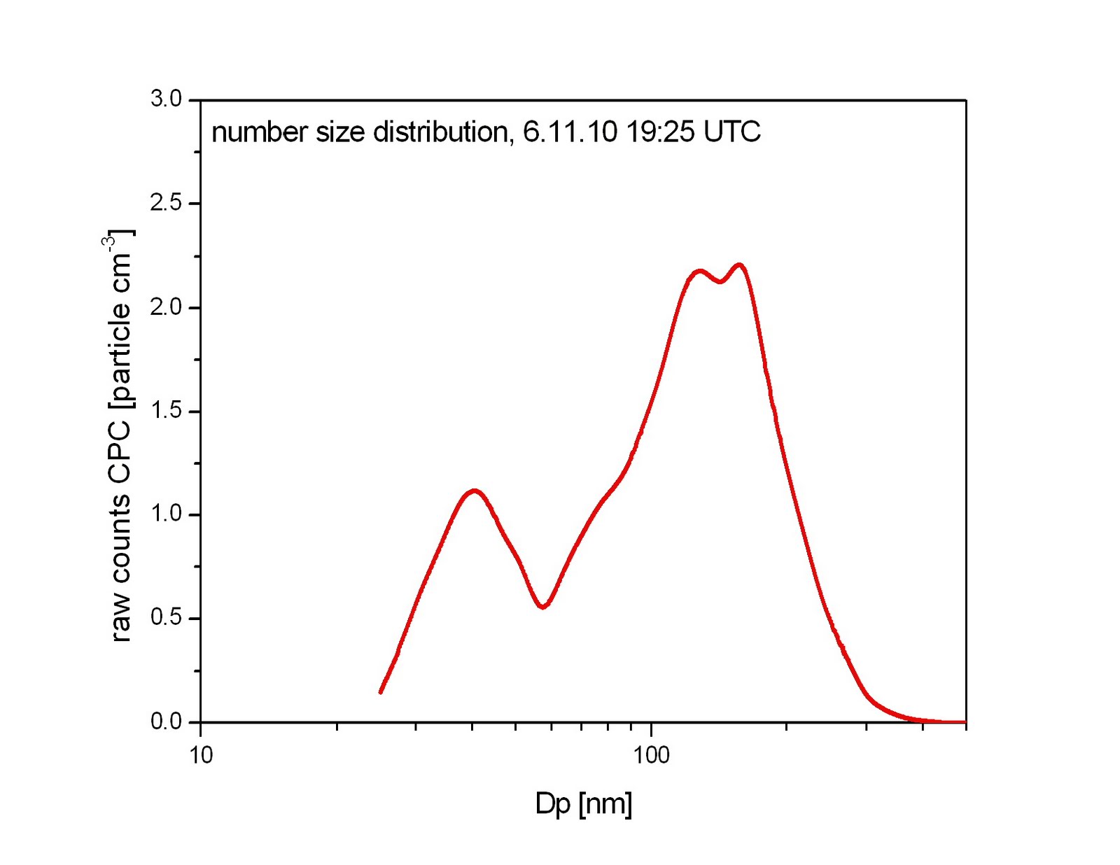
Hier kommen die ersten Ergebnisse der Messungen an Ragged Point. Beispielhaft ist hier eine Größenverteilungsmessung dargestellt. Man beachte die „extrem hohen“ Partikelanzahlkonzentrationen, die wir hier zu verzeichnen haben. Das ist messtechnisch eine echte Herausforderung. Bloß kein winziges Loch in der Aerosolleitung, schon sind die Ergebnisse falsch. Da war natürlich erst mal Lecksuche angesagt. Aber, alle Lecks gefunden und schon wurde am 5.11.10 fleißig los gemessen. Die ersten kappa 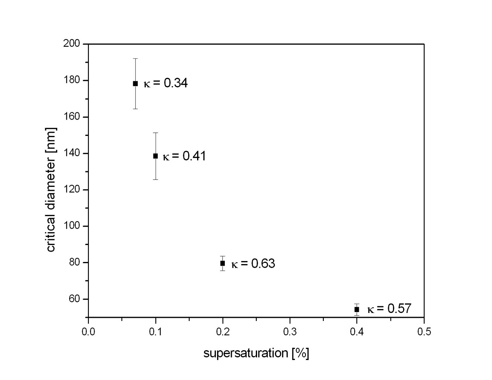 Werte gibt es auch schon, nur so viel: kappa ist hier nicht 0.3 und vor allem abhängig von der Größe des Partikeldurchmessers. Heißt so viel wie, anderer Durchmesser, andere Chemie. So das war´s von der Bodenmessungsseite fürs erste. LG an alle fleißigen Leser, Katrin.
Erweiterte Bodenmessungen
 Seit zwei Tagen werden die Wolken über dem Flughafen von Barbados auch durchgängig vom Ceilometer vermessen. Tiefe Cumulus Wolken mit einer Wolkenunterkante ab 350m werden meisten während der Nacht gemessen. Am Tag beobachten wir über dem Flughafen vermehrt Cirren. Heute waren erste schöne Cumulus Wolken über dem Atlantik zu sehen.
Die Bodenmessungen wurden durch Vaisala Sensoren für Druck, Temperatur und Feuchte erweitert. Auf Grund der Signalübertragung wurde dieser nicht am Masten sondern in der Nähe des Containers (am Pfahl einer Straßenlaterne) montiert.
Samstag, 6. November 2010
Sonne - Wolken - Regenschauer
Hier ein kurzer Eindruck zur aktuellen Wolkensituation über Barbados. Schließlich sind diese ja das Ziel der ganzen Aktion. Leider konnte sich bis jetzt noch keine ungestörten Passatwinde mit durchsetzten. Ex-Hurricane Tomas hat anscheinend immernoch großen Einfluss auf die gesamte Karibik. Somit haben wir die letzten Tage mit abwechselnder Bewölkung leben müssen. Mehrere teils kräftige Regenschauer inbegriffen. Es quillt jeden Tag ganz ordentlich, wobei auch schon die kleinste Wolke Regen bringen kann. Wie auf den Bild zu sehen. Man beachte: Der Regenbogen ist vor! dem Cumulus congestus.

Mit der Wolkenkamera zeichnen wir das Ganze seit zwei Tagen auch auf. Der erste Zeitraffer lässt wunderbar erkennen, dass von Zirrus, über Altostratus bis hin zu niedrigen Culumluswolken alles dabei ist. Nicht wundern. Die Kamera besitzt noch keinen Regenschutz. Deshalb ist zeitweise eine Folientüte zu sehen.
Bleibt abzuwarten, wie sich die Bewölkung in den nächsten Tagen entwickelt. Da im Moment noch nicht geflogen wird, sehen wir das noch ganz entspannt.
Freitag, 5. November 2010
Bodenmessungen an "Ragged Point"
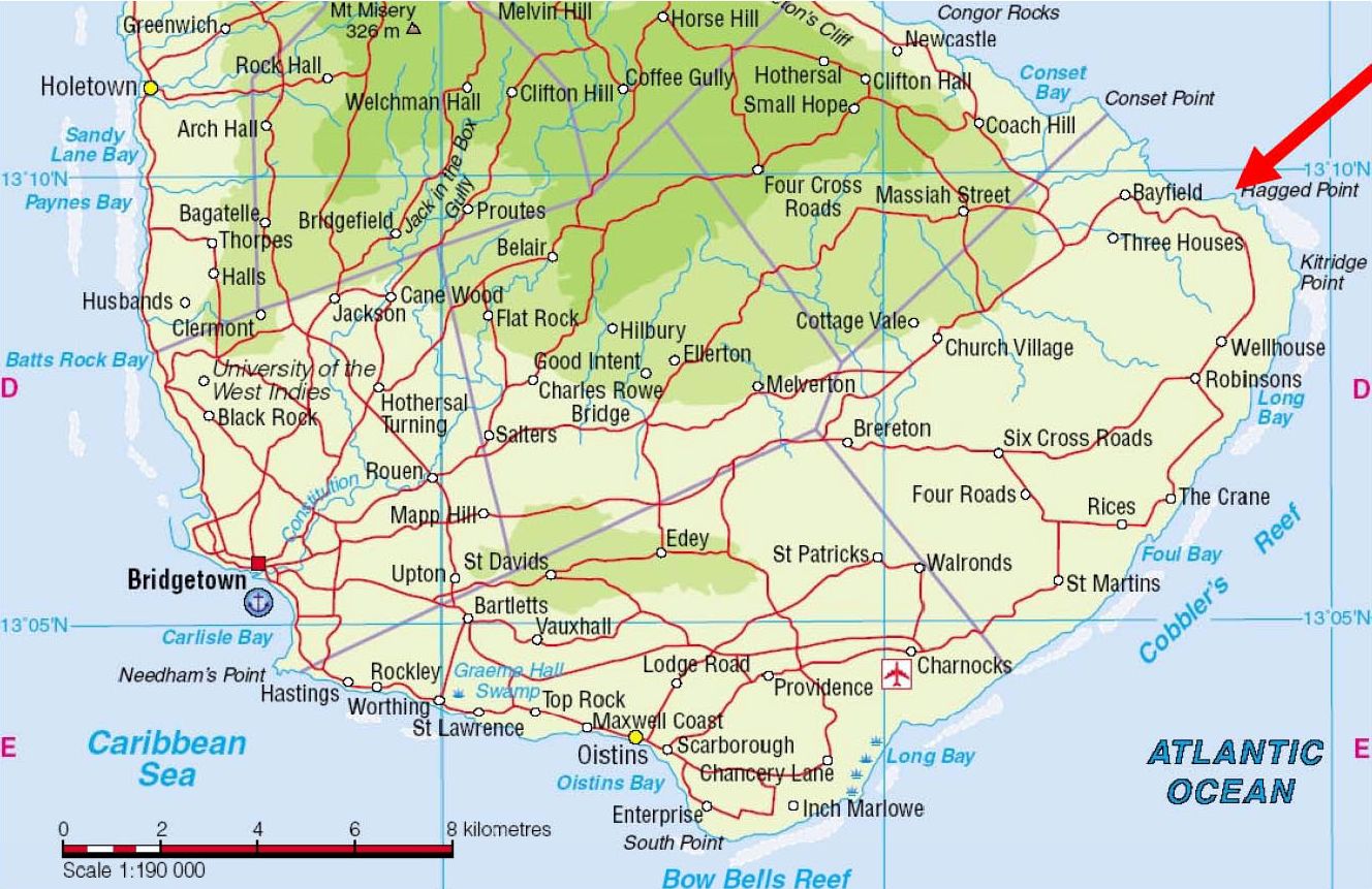 Jetzt muss hier endlich auch mal darüber berichtet werden, dass es außer den Messungen mit ACTOS auch noch Bodenmessungen gibt, die wir hier auf Barbados durchführen. Die finden an „Ragged Point“ statt, nah an der östlichsten Spitze von Barbados, direkt über den Klippen.
 Wir durften unsere Messgeräte dort im Container der „University of Miami“ aufbauen (DMPS und CCNc - jetzt ist der Container ziemlich voll) und auch deren Aerosoleinlass benutzen, der sich auf einem 17m hohen Turm befindet, direkt über den Klippen (ganz schön windig, da oben). Die Schäden, die Hurrikane „Tomas“ dort hinterlassen hat, hielten sich
 glücklicherweise in Grenzen, und Miguel (der die Station von Miami aus betreibt und der uns diese Woche über hilft) hat mittlerweile alles wichtige wieder repariert. Katrin und ich, wir beschäftigten uns während dieser Woche hauptsächlich mit dem Aufbau an „Ragged Point“. Und dank der Mithilfe von Thomas und Miguel können gerade im Moment erste Daten gemessen werden. Eines ist schon jetzt klar: die Luft hier ist momentan sehr, sehr sauber. Eine Folge von "Tomas" und den noch immer auftretenden (und für die Jahreszeit zu häufigen) Regenschauern.
Donnerstag, 4. November 2010
Es geht voran
So, da ich als einzige aufgrund der Ermangelung eines PICT zum Warten verdammt bin, möchte ich Euch zumindest die Fortschritte der anderen Teammitglieder präsentieren:
Zum einen hat heute der FastCPC in seiner neuesten Version zum ersten mal seinen Platz im Inneren von ACTOS gefunden. Erste Bodenmessungen sahen vielversprechend aus. Nun sind wir alle gespannt auf die "airborne" Messungen.
Zum zweiten wurde das Ceilometer in Betrieb genommen und nun können wir sagen: Die Wolkenuntergrenze der Cumuli lag heute im Mittel bei 450 m.
Auch das Strahlungsteam hat allen Grund zu strahlen, da das gestern aufgebaute CORAS heute durchgängig Daten geliefert hat. Und SMART-HELIOS ist auf dem besten Wege, demnächst unter dem Hubschrauber seine ersten Caribik-Messungen zu machen.
 Zwischendurch wurden wir immer mal wieder von teilweise recht heftigen Schauern zu Zwangspausen verurteilt. Aber als Wissenschaftler weiß man sich ja zu helfen, indem man kleine Wolkenstudien betreibt...
Was bleibt zu sagen? Alles wartet auf den Hubschrauber, seine 2 Piloten und.... genau: Das PICT! ;-)
Nachtrag "Tomas"

Hallo Leser,
nachdem Holger bereits von unserem "Überleben" des Hurrikanes berichtet hat, ein kleiner Nachtrag von mir in Form eines Bildes. Die Aufnahme entstand während unserer verzweifelten Suche nach Nahrung und diverser Genussmittel. Da uns nicht ganz klar war, wie hoch die Straße überflutet war, ließen wir ein paar Pkws passieren und probierten es danach selbst. "Türen und Fenster geschlossen halten"... Augen zu und durch!
PS: Auch das haben wir trockenen Fußes überlebt.
Mittwoch, 3. November 2010
Und die Sonne strahlt...
 Staatstrauer in Barbados! Der heutige Tag wurde überschattet vom Staatsbegräbnis des erst letzte Woche verstorbenen Premierministers David John Howard. Unser Beileid!
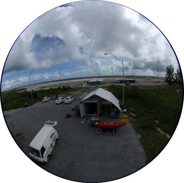
Trotzdem konnten heute weitere Fortschritte verzeichnet werden. Unter der glühenden Sonne von Barbados haben André und ich heute das Bodenmessgerät CORAS aufgebaut, inklusive Spezialvorrichtung für die verwendete Spiegelreflexkamera. Damit sind nun simultan Allsky-Wolkenbilder möglich (und Bilder unseres Camps). Erste Messungen am Nachmittag aus dem sichtbaren Spektrum lassen die stark variable Wolkensituation erahnen.
Auch bei SMART-HELIOS gibt es erste Fortschritte zu vermelden.

Nachdem gestern der Irradianzkopf und der Lagesensor integriert wurden, haben wir heute die neue Verkabelung zwischen Spektrometern und Datenaufzeichnung angebracht und einen erstern Testlauf gestartet. Wenn labview artig ist, sollte morgen auch da die Datenaufzeichnung prinzipiell funktionieren.
Zum Feierabend konnten wir nach Hähnen, Affen, Fröschen, Colibris und Schildkröten eine weitere Spezies im Glenville Gardens entdecken: Glühwürmchen...
Abonnieren
Kommentare (Atom)